Ostland and the "Stahlecker map"
Moderator: Moderator
Forum rules
Be sure to read the Rules/guidelines before you post!
Ostland and the "Stahlecker map"
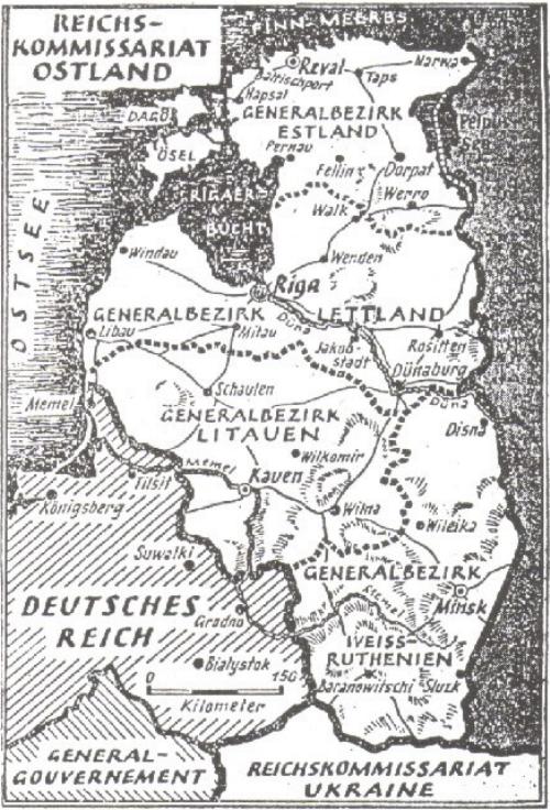
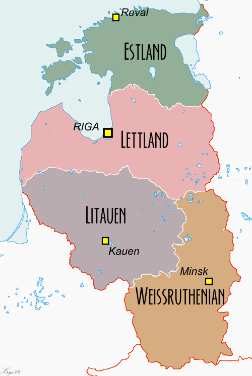
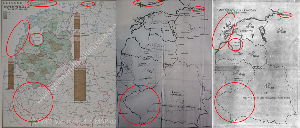
This maybe circumstantial. But when I looked at the socalled Stahlecker map I noticed that it has other borders on the areas then are actually used for the Ostland:
Stahleckers map includes Bialystok. But when...
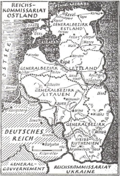
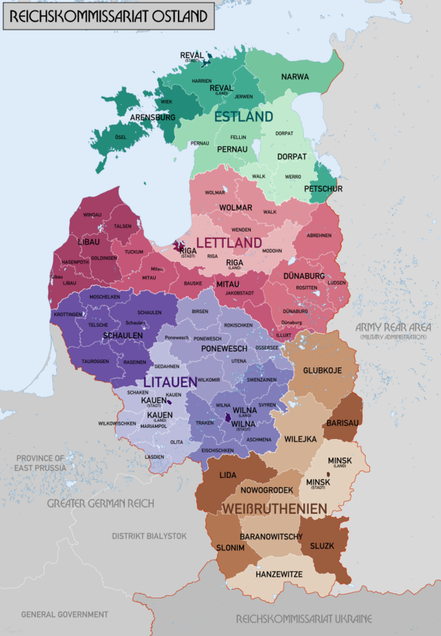
... looking on other Ostland maps it doesn't.
Somehow the Stahlecker map has got a different assignation of territories.
Stahleckers map includes Bialystok. But when...
... looking on other Ostland maps it doesn't.
Somehow the Stahlecker map has got a different assignation of territories.
Re: Ostland and the "Stahlecker map"
More for discussion on this map.
viewtopic.php?f=2&t=1164&p=7229
thread titled: Einsatzgruppen "report" map
M1
viewtopic.php?f=2&t=1164&p=7229
thread titled: Einsatzgruppen "report" map
M1
Only lies need to be shielded from debate, truth welcomes it.
- Kladderadatsch
- Valued contributor
- Posts: 255
- Joined: Tue Jan 03, 2012 11:08 am
Re: Ostland and the "Stahlecker map"
Very interesting find. Nicely spotted, Hektor.
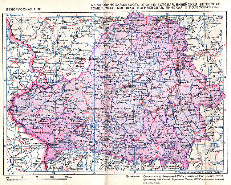
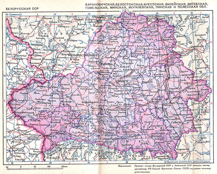
It's easy enough to confirm: the Stahlecker map has used the borders of the USSR as they were established in 1939 after the Soviet invasion of Poland. ("But but but, don't you mean German invasion?!?!" ) In particular, it preserves the outline of the Byelorussian SSR of '39-41, as can be seen clearly in this map via Wikipedia:
(context: http://en.wikipedia.org/wiki/Polish_are ... viet_Union)
On the other hand, the Germans established new borders in the east with the creation of the Reichskommisariats by Fuehrer decree in July of 1941 (http://en.wikipedia.org/wiki/Reichskomm ... Barbarossa), including, crucially for the question here, the creation of the Bezirk Bialystock by the beginning of August (http://en.wikipedia.org/wiki/Bezirk_Bia%C5%82ystok), which cut off the western "nose" of the BSSR and set it aside for (eventual) incorporation into the Greater Reich. So the map had changed, dramatically: the administrative units were different and the BSSR no longer existed in its old borders.
Which kind of does make you wonder, doesn't it, why Stahlecker would have used a map with the old Soviet borders when reporting to his superiors several months later.
Hmm . . .
Der grosse Kladderadatsch war da.
-- D. Eckart Der Bolschewismus von Moses bis Lenin, "Er"
Re: Ostland and the "Stahlecker map"
Kladderadatsch wrote:...
Which kind of does make you wonder, doesn't it, why Stahlecker would have used a map with the old Soviet borders when reporting to his superiors several months later.
Hmm . . .
So my suspicion is perfectly justified. And it is actually something any layman can detect for himself. I understand there were accompanying documents. Does that anyhow match up? Further comparison with Ostland maps or Russian materials will be interesting.
Re: Ostland and the "Stahlecker map"
Not mentioned yet: There is a draft of this "coffin map" with various differences.
From:
The Rumbula Massacre – A Critical Examination of the Facts, Part 1
https://codoh.com/library/document/3198/
The Soviets were notorious map forgers. From my thread here:
The Soviet Union's documented use of document forgeries, Active Measures
viewtopic.php?t=12297
I have also backed up the images posted above, in case they become broken sometime in the future:
Additional maps:
From:
The Rumbula Massacre – A Critical Examination of the Facts, Part 1
https://codoh.com/library/document/3198/
The final blow to the credibility of the Stahlecker statistics comes from a rarely reproduced draft of the infamous “coffin map” attached to the second Stahlecker Report.[132] The draft (Figure 4 below) consists of a more detailed map of the Baltic states and Belarus to which text and figures have been added in pencil. To the upper right is also found, likewise pencilled in, the table of executions from the same report (although with the countries in different order, starting with Estonia instead of Lithuania). There are some small but interesting discrepancies between the draft and the final version:
- The victim figures are not placed within stylized pictures of coffins.
- The Vilnius ghetto (with the figure 15,000 faintly visible to its right) is struck out in the draft but not in the final version. The ghetto of Švenčionys in south-eastern Lithuania is struck out neither in the draft nor in the final version (and also goes unmentioned in the report itself), despite the fact that it is documented to have housed 566 Jews in August 1942,[133] i.e. a considerably higher figure than was indicated for the Liepāja ghetto (300).
- The number of estimated remaining Jews in Weissruthenien was first written as 110,000, then struck out and replaced with the text found in the final version, which gives the figure as 128,000.
- The number of Jews remaining in Minsk is given as 18,000, whereas the final version carries no figure at all. In the report itself it is stated that “about 18 00 Jews” (“rund 18 00 Juden”) remained in the Minsk ghetto, excluding Reich Jews deported there.[134] Since four-digit numbers are written in this way neither in English nor in German it is clear that “18 00” should in fact read “18,000” as on the draft map. According to Yitzhak Arad, however, “(b)etween 45,000 and 46,000 Jews remained in the [Minsk] ghetto” at the beginning of December 1941,[135] whereas in March 1942 the Minsk ghetto, “the largest in Belorussia, had a population of about 49,000 Jews, including the 7,000 brought there from the Reich”.[136] How was it possible for Stahlecker to underestimate the number of remaining Minsk Jews by 27,000–28,000?
- The number of Jews shot in the border area between Lithuania and Germany (East Prussia) – 5,502 – is struck out on the draft but not in the final version.
- The Liepāja ghetto is struck out in the draft but absent in the final version.
- Finally, and most importantly for us in this context, under the number of Jews executed in Latvia – 35,238, the same as in the final version– is written in smaller letters “+ 28.000 (Höh. SS u. Pol.F.)” (cf. Figure 4 b). This in turn appears to have been written over something else that was then erased. Moreover it is clear that the first digit in the 35,238 figure was initially a “2”, which was then overwritten (rather than erased). In the table, on the other hand, “35 238” appears to be the original figure.
Figure 4: Draft of the “coffin map” from the second Stahlecker Report.[137]
Illustration 4 b: Detail of the “coffin map” draft.
The final discrepancy provides us with a key to the Stahlecker statistics pertaining to the Jews of Latvia at the beginning of 1942. Their numbers and fates can accordingly be summed up thus:
Jews shot by Einsatzgruppe A: 35,238
Jews shot by the HSSPF: 28,000
Jews killed in pogroms: 500
Jews remaining in ghettos: 3,750
Total: 67,488
The total here is obviously very close to the number of Jews estimated by Stahlecker to have remained behind at the beginning of the occupation – 70,000. The words “+ 28.000 (Höh. SS u. Pol.F.)” can only be taken to mean that the Rumbula Massacre (whose victim figure is given as 27,800 in the report) alone is ascribed to the Higher Leader of the Police and SS. From this follows that both of the two other major post-15-October mass shootings (in Dauvapils and Liepāja in November and December respectively) must fall under the account of Einsatzgruppe A. However, if we deduct the victim figures reported by Stahlecker for these two mass shootings from the Einsatzgruppe A total of executed Jews at the end of the report period we get (35,238 – 13,384 = ) 21,854. But how then could EG A and their Latvian helpers have killed 30,025 Jews in Latvia up until 15 October 1941, as stated in the first Stahlecker Report, or “about 30,000 Jews” “up until October 1941” as stated in the second report?
The matter gets even more bizarre when we consider that the Einsatzgruppe A total for Lithuania indicated on the “coffin map” – 136,421 – is identical with the number of Jews executed by EG A Einsatzkommando 3 in Lithuania according to a telegram sent by Karl Jäger to the EG A headquarters in Riga on 9 February 1942,[138] which in turn is only slightly higher than the number of Jews listed in the Jäger Report as executed up until 1 December 1941 (135,318).[139] The total of executed Jews in the Jäger Report, however, includes not only 4,934 Reich Jews deported to Kaunas and 3,031 Belorussian Jews shot near Minsk, but also the already mentioned 9,224 Latvian Jews reportedly shot in Daugavpils, Dagda and Kraslava in July and August 1941. But if the Jewish victim figure found in the Jäger Report is contained in the 136,421 figure on the “coffin map”, then these 9,224 Latvian Jews have consequently been erroneously counted among those executed in Lithuania. In turn this would mean that the second Stahlecker Report and the “coffin map” accounts for a total of (67,488 + 9,224 =) 76,712 Latvian Jews – considerably more than the 70,000 Jews estimated by Stahlecker to have been remained in Latvia at the onset of the German occupation. Now, one might argue that 76,712 is closer to our own estimate of some 73,000 Jews remaining in Latvia (including refugees), but if we instead consider the actual number of Jews remaining in the Latvian ghettos, rather than the number reported by Stahlecker, this would bring the total of accounted-for Jews up to 79,146 Jews, making for a surplus of some 6,000 Jews who simply should not be there.
The inevitable conclusion of the above examination is that the statistics found in the Stahlecker Reports are not reliable, but are rather to be understood as statistical fabrications, resulting from exaggerated numbers, bureaucratic confusion, or possibly even from willful falsification. This in turn raises the question: if the Stahlecker Reports present unreliable statistics on the mass killings of Baltic and Belorussian Jews, is it not then possible that at least some of the Jews reported as exterminated did in fact meet an altogether different fate?
The Soviets were notorious map forgers. From my thread here:
The Soviet Union's documented use of document forgeries, Active Measures
viewtopic.php?t=12297
Lamprecht wrote:They even forged "virtually all public maps" of the USSR, according to the chief cartographer:https://archive.is/QvcowSoviet Aide Admits Maps Were Faked for 50 Years
The Soviet Union's chief cartographer acknowledged today that for the last 50 years the Soviet Union had deliberately falsified virtually all public maps of the country, misplacing rivers and streets, distorting boundaries and omitting geographical features, on orders of the secret police.
...
The falsification of Soviet maps, Mr. Yashchenko told Izvestia, began in the late 1930's when the map-making administration was put under control of the security police, then known as the N.K.V.D.
''Even in the post-Stalin time the distortion of generally available maps continued as a requirement of the work of our administration,'' he said. ''This work became senseless with the appearance of space photography,'' which meant foreign countries could make their own extremely accurate maps from satellite data. ''But nevertheless it continued until this year,'' he said.
I have also backed up the images posted above, in case they become broken sometime in the future:
Additional maps:
"There is a principle which is a bar against all information, which is proof against all arguments, and which cannot fail to keep a man in everlasting ignorance -- that principle is contempt prior to investigation."
NOTE: I am taking a leave of absence from revisionism to focus on other things. At this point, the ball is in their court to show the alleged massive pits full of human remains at the so-called "extermination camps." After 8 decades they still refuse to do this. I wonder why...
— Herbert Spencer
NOTE: I am taking a leave of absence from revisionism to focus on other things. At this point, the ball is in their court to show the alleged massive pits full of human remains at the so-called "extermination camps." After 8 decades they still refuse to do this. I wonder why...
Re: Ostland and the "Stahlecker map"
I Actually did research on the subject and i did find some Atlas made by the Reichskommissariat Department regarding Ostland, in 1942. They are available in this German-Russian Archive site: https://wwii.germandocsinrussia.org/de/ ... -riga-1942
They are, as you can see, very similar to the Soviet Coffin-Map. The german description for the Atlas says "Ostland-Atlas for population density, agriculture, economy, etc.". They are not however reporting the war-times statistics, but 1930s. One of the Atlas even shows 1863 statistics. The only Atlas regarding war-time statistics was of January 1941, before Operation Barbarossa. In brief, they're all Atlas regarding either before WW2 or before the German invasion of Soviet Russia. This explain Bialystok being in Belarus, as it was before Germany annex it.
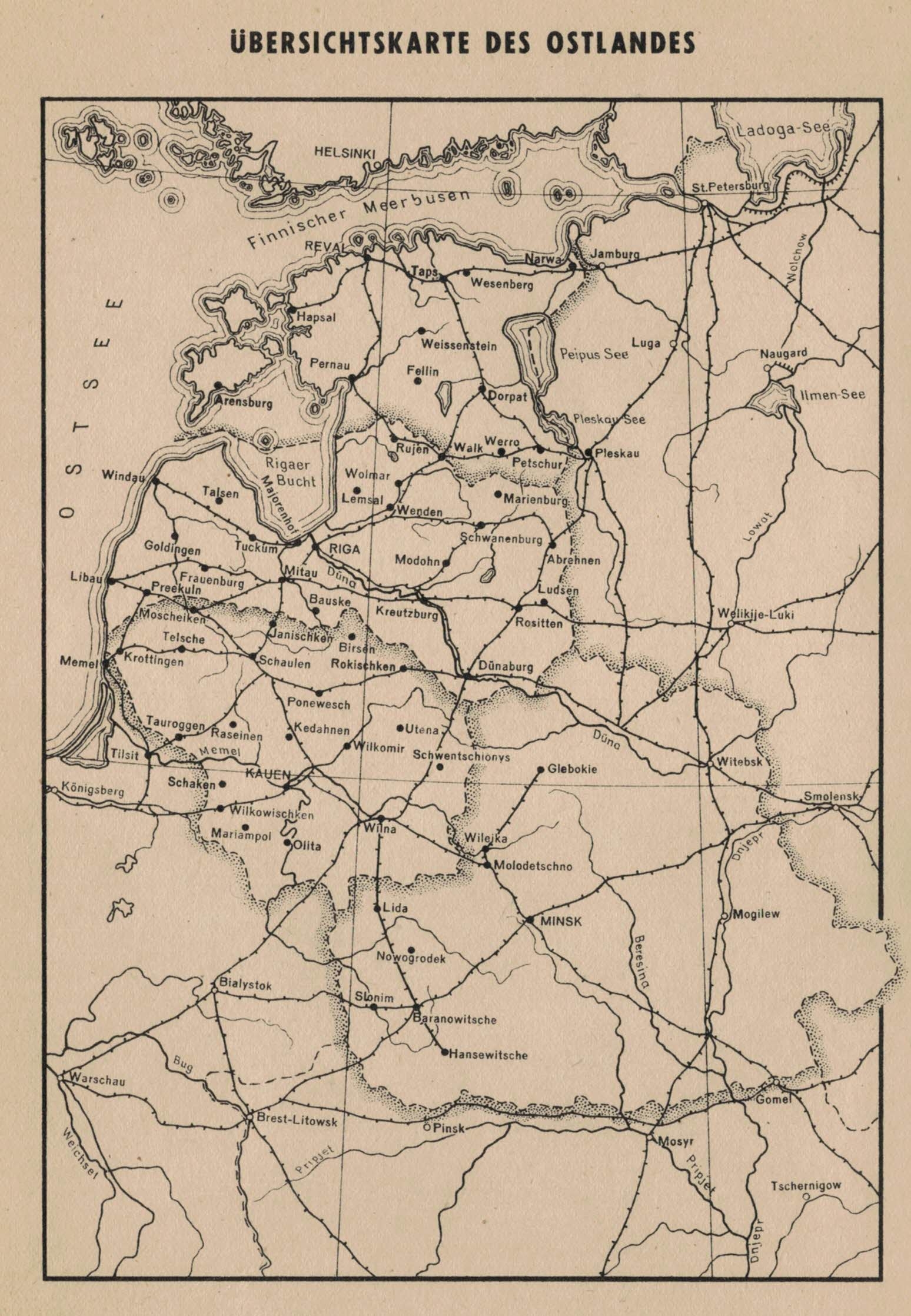
Another Atlas (from 1943) entitled "Übersichtskarte des Ostlandes" shows the Reichskommissariat without Bialystok. This one is taken from this German-Archive website: https://arge-baltikum.de/Karten-de.shtml
This Atlas is also very similar to the other Atlas and the Coffin-Map.
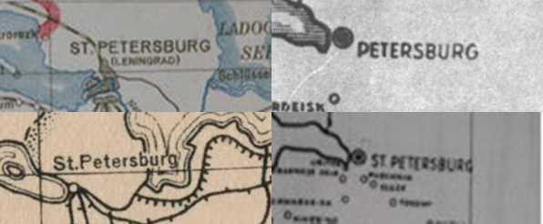
For instance, both the Atlas and the Coffin-Map call Leningrad 'Petersburg/St.Petersburg'.
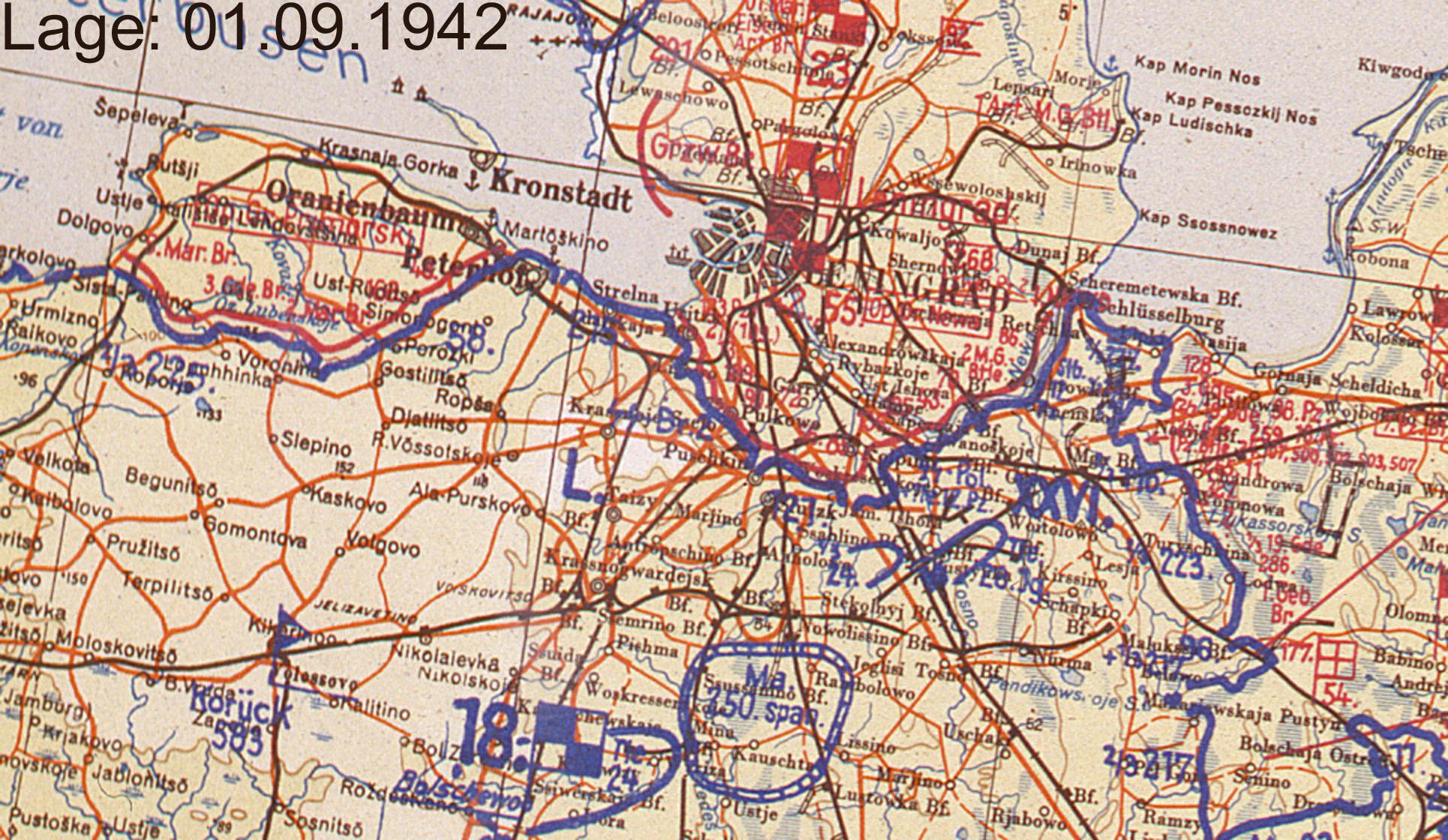
I Checked some of the OKH documents, and none of them call Leningrad Petersburg/St.Petersburg. That's odd as the Coffin-Map was supposed to be a Military map regarding Einsatzgruppen and the SS, not an Administrative Map.
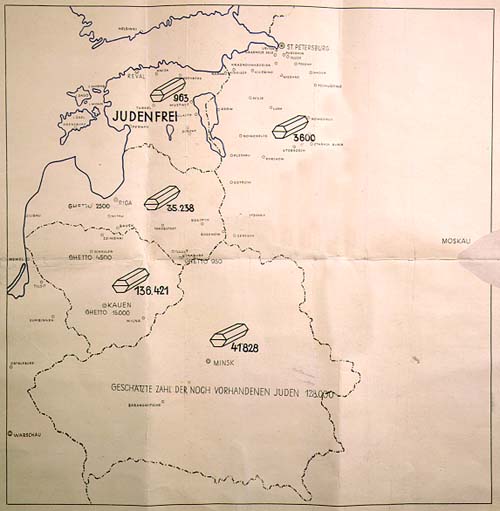
Here's a comparison between the maps: The Atlas, The 1st Version of the Coffin-Map and the Final Version of the Coffin Map.
The 1st Coffin-Map shows Finland and Helsinki and calls Leningrad St.Petersburg as well as the Atlas. While the Final Version of the Coffin-Map removes Finland and the 'St.' from Petersburg, it adds the Rigaer Bucht and the Ostsee in the same format as the Atlas shows. Bialystok stands in all of them, of course.
These are the only Maps by far made by the Administrative Sector of the Reichskommissariats that shows Ostland with Bialystok, and they're very similar to the one the Soviets provided as proof in Nuremberg. What you guys think?
“I cannot teach anybody anything. I can only make them think.” – Socrates
Re: Ostland and the "Stahlecker map"
Excellent finds, Andrewme! And welcome to Codoh.
For reference they'd have older maps available. This can be safely assumed.
But for maps they'd use for release or filing of recent events, they'd use new or 'corrected' maps.
What also is of interest is that the "coffin" as well as the figures accompanying them are different from the other entries into the map. That suggests that this hasn't been done by the same group of people, which would have used the same drawing or writing materials to establish the document (At least in a German office, who worked for a German company will know what I mean there - they are quite pedantic, when it comes to those things.).
It seems the map is mentioned hear in the IMT transcripts:
https://avalon.law.yale.edu/imt/chap15_part06.asp
Stahlecker is occasionally mentioned in the transcripts again.
Re: Ostland and the "Stahlecker map"
Hektor wrote:Excellent finds, Andrewme! And welcome to Codoh.
For reference they'd have older maps available. This can be safely assumed.
But for maps they'd use for release or filing of recent events, they'd use new or 'corrected' maps.
What also is of interest is that the "coffin" as well as the figures accompanying them are different from the other entries into the map. That suggests that this hasn't been done by the same group of people, which would have used the same drawing or writing materials to establish the document (At least in a German office, who worked for a German company will know what I mean there - they are quite pedantic, when it comes to those things.).
It seems the map is mentioned hear in the IMT transcripts:
https://avalon.law.yale.edu/imt/chap15_part06.asp
Stahlecker is occasionally mentioned in the transcripts again.
What is the primary source for this black and white map?
And I can't find Bailystok on that Stahlecker map. Writing is too small. I know on a modern map it forms a triangle with Minsk and Kaunas.
Re: Ostland and the "Stahlecker map"
Werd wrote:....
What is the primary source for this black and white map?
Reich-Kommissariat Ostland.jpg
And I can't find Bailystok on that Stahlecker map. Writing is too small. I know on a modern map it forms a triangle with Minsk and Kaunas.
Just a map that shows the territorial designations for the applicable time frame.
The Stahlecker map shows territorial designations from before Barbarossa. So it's one of the more sloppy forgeries, where you really have to bend it in a way that they would have used an inaccurate map to accurately tell their superiors what they've done in the territories to Jews. Besides that, there would be accompanying documentation describing in summary exactly what they have done. There is documents attributed to him, though. But again, you need to see the originals first to pass any judgement on them. So it's the old hide-and-seek with the supposed evidence again.
They have thousands of supposed documents, which can be scanned and published in book form, but to my knowledge they never did do that...There is however the IMT Nuremberg transcripts in about 40 volumes... Available documents should be able to get away with less than that. So the whole affair lacks transparency only publishing something when they can make it look as if it fits their narrative. There is of course the issue that behind the Eastern Front there were still thousands of stetls and ghettos, which were on lockdown during the occupation. This while they had to still feed a lot of useless eaters among the Jews, no doubt and having supply problems at the same time.
Return to “'Holocaust' Debate / Controversies / Comments / News”
Who is online
Users browsing this forum: No registered users and 10 guests